
OpenSAR: Large-Scale datasets and benchmarks for deeper interpretation of SAR imagery
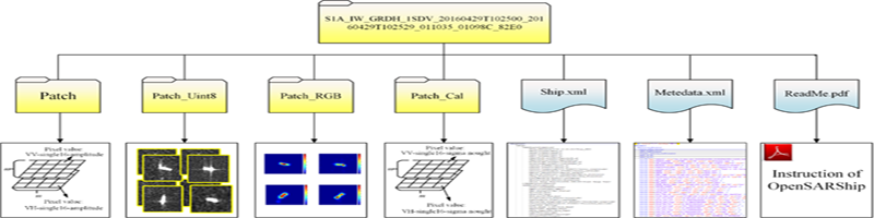
With the rapid development of advanced technologies, especially deep learning, we urgently need a large-scale dataset supporting deeper SAR image interpretation. Currently, we present two public large-scale datasets OpenSARShip and OpenSARUrban dedicated to deeper interpretation of SAR Ship Imagery and urban Imagery respectively. Both of data are collected from Sentinel-1 Imagery. The OpenSARShip dataset consists of 34528 SAR ship chips with automatic identification system (AIS) information covering various environmental conditions.
The OpenSARUrban collection provides 33358 SAR image patches of urban scenes, covering 21 major cities of China, including 10 different target area categories, 4 kinds of data formats, 2 kinds of polarization modes. These benchmarks are provided for the remote sensing community that enables extensive evaluation and investigation of deep SAR image interpretation.
Huang L, Liu B, Li B, et al. OpenSARShip: A Dataset Dedicated to Sentinel-1 Ship Interpretation[J]. IEEE Journal of Selected Topics in Applied Earth Observations and Remote Sensing, 2017.
J. Zhao, Z. Zhang, W. Yao, M. Datcu, H. Xiong and W. Yu, "OpenSARUrban: A Sentinel-1 SAR Image Dataset for Urban Interpretation," in IEEE Journal of Selected Topics in Applied Earth Observations and Remote Sensing, vol. 13, pp. 187-203, 2020.